The 1937 Flood!
Greetings all and hope this day finds
all well and content. From this corner of the world, all appears to be fine. Things
seem to be looking up and especially am glad to see evidence of "Old Mother
Nature" beginning to release her hold on the winter weather and allowing Spring
to be looming. Have seen a few early flowers in bloom and some trees are
beginning to "Bud Out". Ah, the wonders of Spring!
In the past few days,
I have had some computer keyboard time and have been busy pounding out some
sentences and paragraphs in attempting to place some text in this stat that will
go with the attached pictures. Thanks to Hilma for sharing her pictures. I have
not researched any of this material and all of it is just what I recall being
told or what the old brain cells tend to remember. I will probably leave out
some pertinent parts and maybe even a name of two. Have tolerance with me here
and correct me if you so desire.
Please remember that pictures that were
taken back in the thirties, for the most part, were not the best of quality.
Also, be advised that most of the pictures that I use will have to be scanned
and converted to a digital image, thus some quality will be lost in this
process.
In January of 1937, It did not
rain for forty days and forty nights. To the people in Rockport and other areas
along the Ohio River and the tributaries of the Ohio, it may have seem like it
rained for that length of time. Old timers say that it rained every day from the
first to the twenty-first day of January. It was not just showers, but hard
rains, off and on, both day and night. The water began to rise but there was no
great concern on the part of the citizens. Rockport was built on "High Land"
above the bank of the river, but there were several houses in the flood prone
areas. They were accustomed to floods every few years and just moved to higher
ground and returned when the floodwaters receded. There was just no way that the
floodwaters could ever approach the Railroad Bridge. People in the flood prone
areas took about the same precautions that they had with preceding floods. Some
moved their things to upstairs rooms and before the water crested, the water
covered the entire house.
The greatest volume of water ever known to pass
along the Ohio's River's southern shores flooded all Ohio River communities
during the last two weeks of January 1937. Ohio River levels on January 26-27
were the highest known from Cincinnati, Ohio to Paducah, Kentucky. Crests were
20 to 28 feet above flood stage and 4 to 9 feet above previous records. Six to
19 inches of rain fell in the Ohio River drainage area during January 13-25,
1937. These totals have never before, or since, occurred over such a large area
of Kentucky, Ohio, Illinois and Indiana. January 1937 remains as the wettest
month ever recorded in this area of the Ohio River basin. The Green River and
other tributaries of the Ohio River just did not have anywhere to drain their
flood waters. Thus, the Green and other Rivers rose to levels that had never
been experienced.
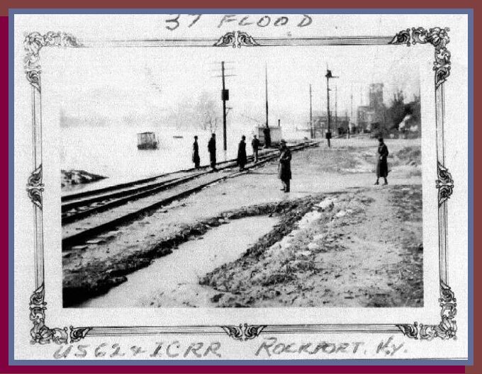 Doesn't this picture just say it all.
Notice the date at the top and the location at the bottom. Yes, that is the
"Flood Waters" of Green River in January 1937. In the background is the Rockport
Railroad Bridge, spanning the Green River, and the "Flood Waters" are just about
up to the crossing. It must have been Sunday when this picture was taken as some
of the people seem to be in their finest. In about the center of the picture,
what appears to be a man and a woman, probably "Husband and Wife", seem to have
come down to the river to look at the floodwaters. The three on the left, of the
group of four, seem to be listening to the other man. I would suspect that he
may be an I C Railroad Employee and may trying to keep people off the bridge.
The boats are probably the "Ferry Boats" and someone has tied them up, and out
of the way, of the floodwater. Just beyond the utility pole, on the left, is a
tree. When I was roaming the "Green River" area, there was a single Maple Tree,
just down from the railroad tracks, and it appears to be the same tree. I can
remember other flood waters almost coming up to this Maple Tree. During the
"Floods", in our time, we would mark the "Floodwater Level" with a stick. Just
drive a stick at the water's edge and come back a hour later or even overnight
and recheck your stick. Then you could estimate the "Rise" or "Fall" of the
floodwaters. From the base of this Maple Tree, it must have been twelve feet up
to the railroad bed. To us, if the floodwater ever rose to the base of the Maple
Tree, it would have been an enormous flood. This 1937 flood was some ten, or so,
feet higher that the base of the Maple Tree. Now, that is some flood.
Doesn't this picture just say it all.
Notice the date at the top and the location at the bottom. Yes, that is the
"Flood Waters" of Green River in January 1937. In the background is the Rockport
Railroad Bridge, spanning the Green River, and the "Flood Waters" are just about
up to the crossing. It must have been Sunday when this picture was taken as some
of the people seem to be in their finest. In about the center of the picture,
what appears to be a man and a woman, probably "Husband and Wife", seem to have
come down to the river to look at the floodwaters. The three on the left, of the
group of four, seem to be listening to the other man. I would suspect that he
may be an I C Railroad Employee and may trying to keep people off the bridge.
The boats are probably the "Ferry Boats" and someone has tied them up, and out
of the way, of the floodwater. Just beyond the utility pole, on the left, is a
tree. When I was roaming the "Green River" area, there was a single Maple Tree,
just down from the railroad tracks, and it appears to be the same tree. I can
remember other flood waters almost coming up to this Maple Tree. During the
"Floods", in our time, we would mark the "Floodwater Level" with a stick. Just
drive a stick at the water's edge and come back a hour later or even overnight
and recheck your stick. Then you could estimate the "Rise" or "Fall" of the
floodwaters. From the base of this Maple Tree, it must have been twelve feet up
to the railroad bed. To us, if the floodwater ever rose to the base of the Maple
Tree, it would have been an enormous flood. This 1937 flood was some ten, or so,
feet higher that the base of the Maple Tree. Now, that is some flood.
By January 21 the waters were higher than they had ever been before and
Rockport and other river towns, and the larger cities like Louisville knew that
this was going to be the "Flood" of all Floods. Trains stopped running due to
water being over the tracks. The electrical and water systems in most areas were
knocked out. The roads in and out of Rockport were under water. The Rockport
Ferry could not land as it was tied up some fifty or so feet higher than the
normal river channel.
When the flood waters receded, it left millions of
dollars in damages. Things slowly began to return to normal. Both Rockport and
Ohio County schools reopened, having been out about a full month. Things were in
shambles but the people faced restoring and rebuilding with a strong resolve;
however, it was one disaster that would be forever talked about.
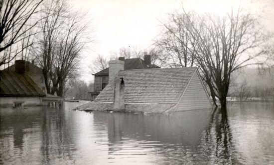
In Point Pleasant Ohio, Ulysses S. Grant's birthplace was nearly submerged
by flood waters on January 26, 1937. Ohio Historical Society collection.
The following came from the internet-Source unknown:
The Great Flood of 1937:
One of the worst floods in American
history began in the Ohio River Valley in late January 1937. And of all the
cities along the Ohio, Louisville was the worst hit. Over 19 inches of rain
during January left more than 60% of the city under water and without power
during the cold weeks at the end of January and beginning of February 1937. The
present Old Louisville neighborhood did not escape. Only the higher portions of
Third Street and the high ground around Central Park escaped the waters.
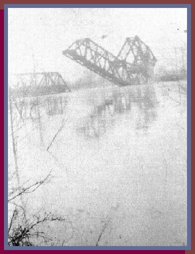 The Rockport Railroad
Bridge in 1937. It seemed to have held together during the times of the flood.
It is difficult to make out, but if you look close you can see something large
and dark on the portion of the bridge that is between the middle pier and the
bank pier on the Rockport side. Those are railroad cars and they are filled with
something, probably coal. They were placed on the bridge to help prevent the
swift waters of the flood from washing away or moving the two piers. Evidently
it worked, as the piers and bridge are still there.
The Rockport Railroad
Bridge in 1937. It seemed to have held together during the times of the flood.
It is difficult to make out, but if you look close you can see something large
and dark on the portion of the bridge that is between the middle pier and the
bank pier on the Rockport side. Those are railroad cars and they are filled with
something, probably coal. They were placed on the bridge to help prevent the
swift waters of the flood from washing away or moving the two piers. Evidently
it worked, as the piers and bridge are still there.
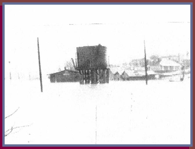
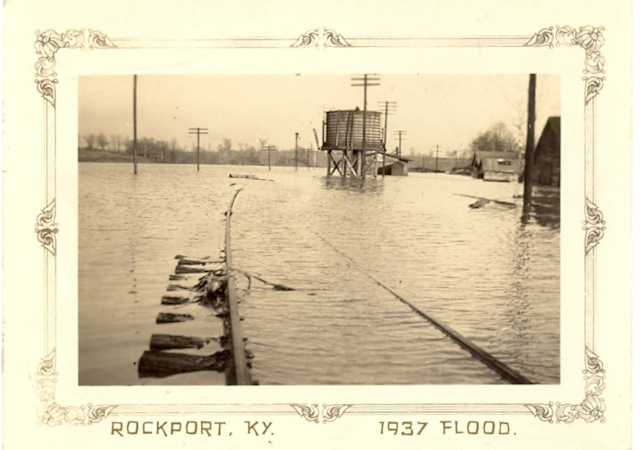
I do apologize for using this picture,
as it is not very clear, but it seems to tell the story so well. I will try to
pick out a few landmarks and maybe you can spot a few. For starters, the large
object in about the center of the picture is the IC Railroad's water tank. This
is where the steam engines, "Took On" water, and with a full water reservoir,
that could be turned into steam, they could continue for another hundred miles
or so. Just behind the water tank is the Rockport Depot. At one time, this depot
was the hub of Rockport. Even the mail was dropped off and loaded from this
center. It looks like the flood water may have been a few feet over the railroad
tracks. Just to the right of the picture was a gravel road that came down from
the "Overhead Bridge" area to the flats of the railroad track area. Hershel
"Nippy" Iller lived about half way down the hill and on the right. Don't know if
he was living there at the time of the flood, but he lived there most of his
life. Notice the three of more buildings between the utility pole and the water
tank. Manse and Marie Jones lived in the house on the corner and again, doubt if
they lived there during the late thirties. Don't remember anybody else living in
the other buildings. Think that they may have been some sort of a railroad
storage or staging area, maybe built during the bridge construction. Other than
Manse and Marie living on the corner, I can't remember anyone else living in
these buildings. On the left and up the hill past the Jones's house is another
landmark that can be seen. It is house on the right of the picture and about
center. Think that Beverly Stewart lived in this house in the late forties. I
have no idea of the history of the house prior to that time frame. C. E. Durbin
became the Depot Agent in 1952 and he moved his family into this house when they
first settled in Rockport. Now, all is gone. Houses and wooden structures age
and some catch fire. Others are torn down. People age also and they are put to
rest while their offspring continue on and offer their services to the new era.
This flood passed and other events and occurrences combined to shape and mold
the people of the community. Other times and other stories. Memories live on.
;>)